Exploring the Ocean Floor
- The arrangement of physical features in an area
- the study of underwater ground characteristics
- measure ocean depth
- chart topography
- Sounding [Posidonius (85 BC)]
- Let out 2 km (1.25 mi) line with attached weight until touched
- sound signal (ping) bounces off bottom, calculate dist
- Precision depth recorder (PDR) [WWII]
- high frequency sound beam
- Multibeam echo sounders [today]
- SeaBeam - able to scan area 60 km (37 mi) wide
- Satellite mapping from space [most recent]
- microwave beams, measure gravitation irregularities
- Early Measurements "Sounding"
- Involve a line with a weight on the end
- Knots are tied at different (premeasured) points
- Throw overboard and see at what knot the line stops
- Knotted line is called PLUMB LINE
- Posidonius (85 BC) used 2 km lines
- SOund Navigation And Ranging
- Single Beam Sonar "Echo sounders"
- Uses echoes to determine ocean floor features
- Sound ‘pings’ off floor. The return time is recorded
- Must know how fast sound travels in water
- Use started in early 1900s
- Sound in water travels much faster than sound travels in air
- Avg speed in Air = 340 m/s
- Avg speed in Water = 1500 m/s (3355 miles/hr)
- Depth can be measured by using the following equation:
- d is sea depth
- t is time recorded
- v is avg sound speed (velocity) in water
- What's the deal with that ½?
- For sounding to work, the beam must travel down to the bottom, then return.
- That counts as 2 trips, down and up.
- Therefore, you need to divide the distance (depth) in half to compensate. You just want the "down" measurement.
- It took 10 seconds for a sound pulse to travel through the water and return to the sonar instrument. Calculate the sea depth.
- d = ½ t * v
- d = ½ (10 seconds) (1500 meters/second)
- depth = 7,500 meters
- Increased precision and accuracy
- Precision Depth Recorder (PDR)
- high frequency sound beam
- provides better recording information
- can plot over a range of 400 fathoms (730 m) on a page about 50 cm wide
- use started in World War II
- Multibeam Sonar
- Uses many ‘pings’ to create 3D images
- Can locate shipwrecks, downed planes, schools of fish
- Use of microwave beams
- Seabed causes distortions to gravitational forces
- Differences measured against norms to determine topography
- Mirrored and magnified when compared to the continents.
- Largest underwater mountains are TALLER than on land
- Underwater plains are larger and flatter than those on land
- Highest altitude
- Altitude: 8,850 m (29,035 feet) tall
- Tallest mountain
- Altitude: 4,205 meters (13,796 feet)
- But if measured from underwater, it's over 10,000 meters high (32,000+ feet)
- Deepest place on Earth
- Depth: 10,994 meters (36,070 feet)
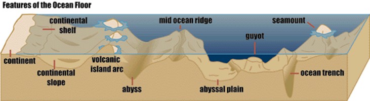
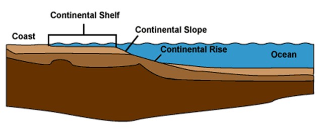
- Region closest to land
- Has 3 parts
- Continental Shelf
- Underwater extension of the coastal plain
- Extends from shoreline to slope
- Steep slope leading from the edge of a continent down to the seafloor
- Hill of sediment at the bottom of the steep slope near the edges of continents
- Seamounts and Island Chains
- Cone Shaped undersea mountains of volcanic origin
- May occur in chains (ex: Hawaii)
- Often, active volcanic island at one end
- Guyot: seamount with a flat top
- Chains of volcanic active islands next to deep sea trenches
- Happens due to subduction
- subduction: one tectonic plate shifts beneath another
- How are island chains formed?
- “Hot spot” or “Volcanic Plume” stays in place while tectonic plate slides past it.
- The Ring of Fire is a ring of volcanoes around the Pacific Ocean that result from subduction of oceanic plates beneath lighter continental plates.
- Most of the Earth's volcanoes are located around the Pacific Ring of Fire because that's the location of most of the Earth's subduction zones.
- Flat, featureless area making up a large part of the seafloor
- Made up of eroding earth, sediments, and benthic ooze
- Underwater mountain range where new seafloor is created
- Creates New Oceanic Crust (seafloor spreading)
- **largest is the Atlantic Mid-Ocean Ridge
- Magma rises, cools, and turns into rock.
- The new rock is pulled away by the two tectonic plates diverging (pulling apart)
- Newer rocks will be found close to the spreading zone. Older rocks will be further away.
- Deepest parts of the ocean
- Narrow, canyon like
- Deepest: Mariana’s Trench in Pacific Ocean: "Challenger Deep"
- **Earthquakes and volcanic activity associated with trenches**
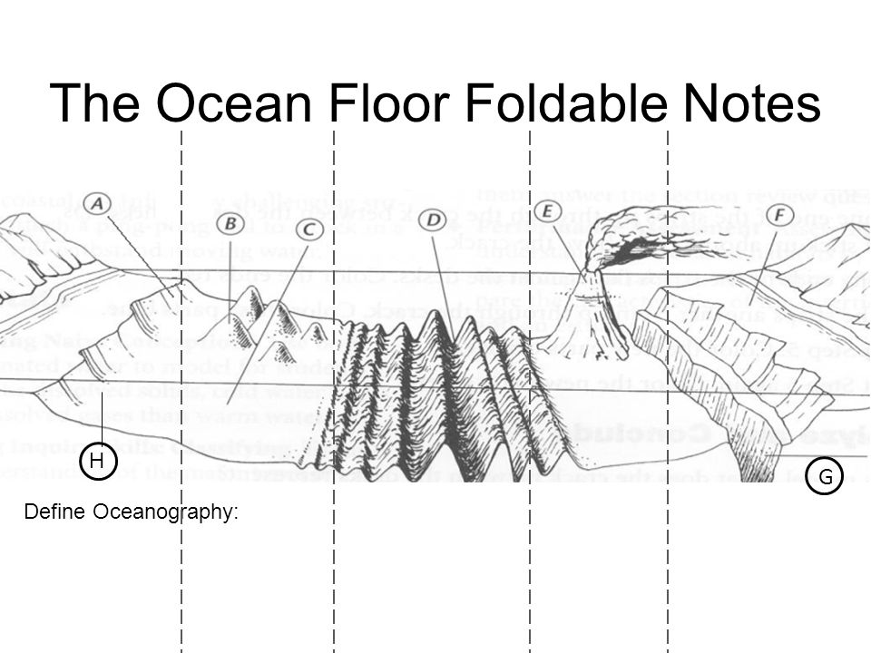
- Continental slope
- Seamounts
- Abyssal plain
- Mid-Ocean ridge
- Island arcs
- Continental shelf
- Trench
- Continental rise